 The River Thames Guide
EXPLORE THE THAMES
Visiting Cleeve Lock near Goring
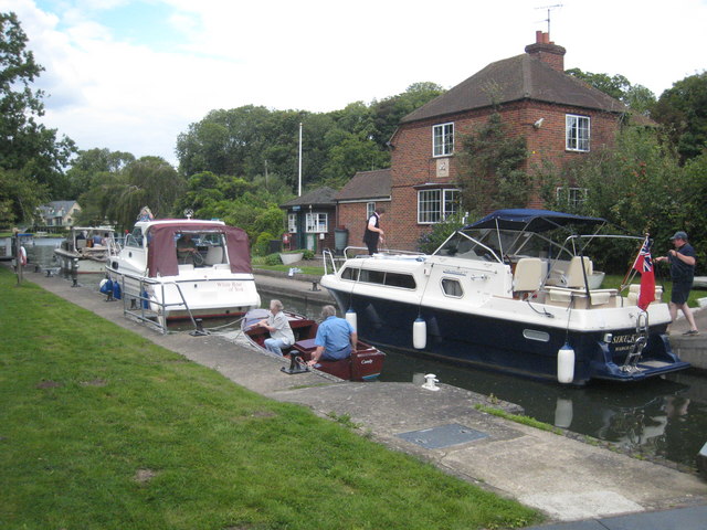
Cleeve Lock is on the Thames at Cleeve, just upstream of Goring. The postcode is RG8 0JY. Plan the walking approach and use public parking rather than treating the lock postcode as a parking destination.
The official Thames Path map helps link a visit with riverside walks around Goring and Streatley. Check crossings and any diversions before choosing a circular route.
Preparing for the longer upstream reach
Cleeve’s listed services include a toilet, a tap for portable drinking-water containers and a bulk water point. Check availability before departure, particularly when preparing for the longer journey towards Benson.
EA facilities guide, checked 4 October 2026.
EXPLORE THE THAMES
The shortest reach between Thames locks
The river distance from Cleeve to Goring Lock is 1.00 km (0.62 miles). This is the shortest reach between neighbouring locks on the non-tidal Thames—just over half a mile.
Upstream, the 10.46 km (6.50-mile) reach from Benson is the longest. Cleeve therefore sits between both extremes.
Lock fall and water depth
Cleeve has a small change in water level. The earlier guide gave a rise of 0.69 metres; the Environment Agency’s current dimensions table gives a fall of 0.89 metres. Neither figure is the depth available for a boat.
EXPLORE THE THAMES
Cleeve Lock and its changing weirs
A flash lock was documented here in the sixteenth century. The place name has been linked with cliff or clift, describing a channel cut by water.
An oak pound lock was built in 1787, rebuilt in stone in 1874 and converted to hydraulic operation in 1966–67.
The old lock house stood by the tail gates. Its replacement, built in 1958, stands alongside the centre of the lock chamber.
Before 1982, the weirs used the older paddle and rymer arrangement, in which removable paddles controlled the water flow. The original guide describes their replacement by radial weirs.
Two locks, one keeper
Cleeve and Goring were often managed together in their early years. Thacker records a recommendation in January 1869 to separate their management. Their shared past complements the unusually short river reach between them.
Research source: F. S. Thacker, The Thames Highway: Cleeve. Checked 4 October 2026.
EXPLORE THE THAMES
Lock gardens, wildlife and a riverside verse
The guide’s earlier account describes a lock keeper with a strong interest in natural history, tending flower beds, shrubs and fruit trees to attract wildlife.
Recorded visitors include kingfishers, geese and other river-feeding birds, with mink also noted.
The Michael O’Day verse
A plaque on a picnic table was recorded in our original guide with this anonymous boating verse:
Sacred to the memory of Michael O’Day
Who died maintaining his right of way
He was right, dead right, as he sailed along
But he’s just as dead as if he’d been wrong— Anon.
It is retained here as part of the lock’s local character; the account does not confirm whether the original plaque is still in place.
ON THE WATER
Boating through Cleeve Lock
Benson Lock is 10.46 km (6.50 miles) upstream. The next lock downstream is Goring Lock, 1.00 km (0.62 miles) away by river.
Published lock dimensions
- Length
- 40.71 m
- Width
- 5.53 m
- Fall
- 0.89 m
- Upper sill depth
- 2.13 m
- Lower sill depth
- 2.22 m
Source: Environment Agency distances and measurements. Published dimensions and sill depths do not guarantee navigable clearance. Check water levels, the full guidance and current restrictions.
Consult the lock keeper service and follow the instructions displayed at the lock.
Neighbouring reaches: cruising estimates
| Reach | km / miles | EA estimate |
|---|---|---|
| Benson → Cleeve | 10.46 / 6.50 | 79 minutes |
| Cleeve → Goring | 1.00 / 0.62 | 8 minutes |
The Environment Agency estimates assume 8 km/h. Add waiting and lock-passage time; conditions can lengthen journeys. These are river distances, not walking distances.
Facilities at Cleeve Lock
- card and contactless payments
- toilet
- drinking water tap (for portable containers only)
- bulk supply water point
Checked 4 October 2026 against the Environment Agency facilities guide. Availability can change; check the official guide and signs on site.
BEFORE YOU SET OFF
River conditions at Cleeve Lock
Check stream warnings and navigation closures separately. A lack of stream warnings does not confirm that a lock is open.
For the latest information, check the official river conditions service below.
Questions about Cleeve Lock
How far is Cleeve Lock from Goring Lock?
The river distance is 1.00 km, or 0.62 miles. It is the shortest reach between neighbouring locks on the non-tidal Thames.
What is the fall at Cleeve Lock?
The Environment Agency publishes a fall of 0.89 metres. This means the change in water level through the lock, not navigable water depth.
Where is Cleeve Lock?
It is just upstream of Goring-on-Thames in Oxfordshire. The postcode is RG8 0JY.
About this guide
Published by The River Thames Guide. Research additions, measurements and facilities checked 4 October 2026. Sources are linked beside new material; earlier local accounts are retained where identified. Check changing access and navigation arrangements before travelling.
Contains public sector information licensed under the Open Government Licence v3.0. New research is written in original wording; no third-party archive images or maps have been copied. Existing photograph credits and licences are retained.


