 The River Thames Guide
PLAN YOUR VISIT
Visiting Grafton Lock and the Thames Path
Grafton is a countryside stop on the upper River Thames. The neighbouring locks are Buscot upstream and Radcot downstream, making this a useful place to pause on a riverside walk or boating journey.
Use the official Thames Path route map to plan your approach, river crossings and return journey. The river distances below are for boats; they are not measured walking routes.
Directions and access
The Environment Agency gives OX18 2RY as the lock postcode and SU 27146 99233 as its grid reference. Check public rights of way before setting out: a lock postcode does not establish public parking or vehicle access. Riverside paths can be muddy or flooded, and gates and uneven surfaces may affect access.
THE STORY OF THE RIVER
Grafton Lock and the old Day’s Weir
The pound lock dates from 1896, replacing the earlier flash weir known as Day’s Weir. A flash weir released water to carry boats through; the later pound lock allowed boats to move between levels inside a chamber.
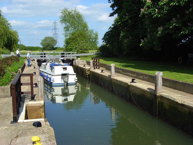
Our original guide describes the heavy wooden balance beams and the traditional appearance of the manual-beam lock. This characteristic form links Grafton with the working landscape of the late nineteenth-century Thames; it does not mean that every timber is original.
Opening day and the first keeper
Thacker gives 26 November 1896 as Grafton’s opening to traffic and names Patrick Lee as its first keeper. Lee later moved to Blake’s Lock on the Kennet.
Research source: F. S. Thacker, The Thames Highway: Grafton. Checked 6 October 2026.
PROTECTED RIVERSIDE LANDSCAPE
Grafton Lock Meadow
Grafton Lock borders Grafton Lock Meadow, a designated Site of Special Scientific Interest. The original guide referred to English Nature; the designation is recorded in the government’s current Grafton Lock Meadow SSSI entry.
Enjoy views from public paths and respect signs and boundaries. A nature-conservation designation does not automatically give public access across the whole meadow.
PAUSE BY THE WATER
Otters and wildlife at Grafton Lock
These wildlife details come from our earlier local account, not a current survey or a guarantee of sightings.
Otters are a memorable part of Grafton’s local story. Our earlier guide described a photograph on the lock office wall of an otter leaving the water close to the gates. It also recorded lock keeper Keith Webb working as a wildlife trainer with BBOWT, the Berkshire, Buckinghamshire and Oxfordshire Wildlife Trust. These are historical recollections, rather than a statement about current staffing or displays.
The original account records red kites, buzzards, kingfishers and grass snakes, together with dragonflies, nymphs, sedges and mayflies. It linked increasing insect numbers at the time with reduced water pollution; this is not a current assessment of water quality.
There are also historical reports of a hummingbird hawk moth and a swallowtail near the lock. These unusual sightings should not be taken as a promise of what visitors will see today.
Watch quietly from the riverside paths. Otters are elusive, and wildlife sightings depend on season, weather and chance.
ON THE WATER
Boating through Grafton Lock
Buscot Lock is 5.37 km (3.34 miles) upstream. The next lock downstream is Radcot Lock, 2.98 km (1.85 miles) away by river.
Published lock dimensions
- Length
- 34.59 m
- Width
- 4.59 m
- Fall
- 1.11 m
- Upper sill depth
- 1.67 m
- Lower sill depth
- 1.44 m
Source: Environment Agency distances and measurements. Published dimensions and sill depths do not guarantee navigable clearance. Check water levels, the full guidance and current restrictions.
Consult the lock keeper service and follow the instructions displayed at the lock.
Neighbouring reaches: cruising estimates
| Reach | km / miles | EA estimate |
|---|---|---|
| Buscot → Grafton | 5.37 / 3.34 | 41 minutes |
| Grafton → Radcot | 2.98 / 1.85 | 23 minutes |
The Environment Agency estimates assume 8 km/h. Add waiting and lock-passage time; conditions can lengthen journeys. These are river distances, not walking distances.
Facilities at Grafton Lock
- card and contactless payments
- toilet - available during Lock and Weir Keeper hours only
- shower – available during Lock and Weir Keeper hours only
- bulk supply water point
Checked 6 October 2026 against the Environment Agency facilities guide. Availability can change; check the official guide and signs on site.
Dry-weather passage restrictions
Checked 6 October 2026: the EA still lists restrictions from St John’s to Osney, covering this lock. Passages during keeper hours are limited to one movement each way per half-hour. Overnight closures run from 30 minutes before duty ends until 30 minutes after duty starts the next day. Check current hours and the full notice when planning your arrival.
EA dry-weather navigation notice; arrangements remain subject to review.
BEFORE YOU SET OFF
River conditions at Grafton Lock
Check stream warnings and navigation closures separately. A lack of stream warnings does not confirm that a lock is open.
For the latest information, check the official river conditions service below.
Questions about Grafton Lock
Where is Grafton Lock?
Grafton Lock is on the upper River Thames in Oxfordshire, between Buscot and Radcot locks. Its lock postcode is OX18 2RY.
Can you see otters at Grafton Lock?
Otters feature in the local wildlife record, but sightings are unpredictable. Watch quietly from public paths and avoid disturbing the riverbanks.
Are there toilets at Grafton Lock?
The Environment Agency lists a toilet and shower available during lock keeper hours only. Check the current facilities guide before relying on them.
About this guide
Published by The River Thames Guide. Research additions, measurements and facilities checked 6 October 2026. Sources are linked beside new material; earlier local accounts are retained where identified. Check changing access and navigation arrangements before travelling. Older staff recollections and rare wildlife sightings are identified as historical reports.
Contains public sector information licensed under the Open Government Licence v3.0. New research is written in original wording; no third-party archive images or maps have been copied. Existing photograph credits and licences are retained.


