 The River Thames Guide
EXPLORE THE THAMES
Visiting Temple Lock and the Thames Path
Temple Lock lies between Hurley and Marlow, near Bisham. The lock postcode is SL7 2FL. Use the official Thames Path map to plan the public approach and allow for diversions.
Temple Footbridge, upstream of the lock, is closed. The Environment Agency’s project update explains that the bridge requires replacement following structural investigations. Follow the signed diversion and check the latest information before choosing a circular walk.
The footbridge closure is separate from navigation through the lock. Boaters should use the river conditions and restriction links below.
Footbridge closure: plan the return route
Checked 4 October 2026: the Environment Agency still lists Temple Footbridge as closed to walkers, with a signed diversion. Its navigation measurements also record removal of the bridge’s central arch. Do not follow an older circular-walk description that depends on crossing here.
Walking closure and facilities · Bridge information for boaters. Check current navigation restrictions separately.
EXPLORE THE THAMES
The Knights Templar and Bisham Abbey
The name Temple recalls the Knights Templar, who owned land and ran mills in this area during the Middle Ages. Their important base at nearby Bisham Abbey is documented in Historic England’s account of the monastic and manorial complex.
Bisham later became associated with Henry VIII’s fourth wife, Anne of Cleves, through her divorce settlement. Today it is Bisham Abbey National Sports Centre. Check the venue’s visitor arrangements before planning to enter the grounds.
EXPLORE THE THAMES
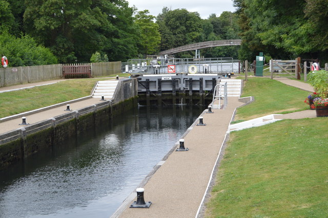
Temple’s two lock chambers
Temple is one of the Thames’s unusual double locks, with two chambers side by side. The Thames Navigation Commissioners built the first pound lock in 1773.
In 1890, the Thames Conservancy added a new lock alongside it. The older chamber was retained and adapted for skiffs, punts and other light pleasure craft.
The newer chamber became the working navigation lock. Our original account describes the old lock as sealed off and overgrown, with an abandoned boat that had sunk there. That detail belongs to the lock’s recorded history; the old chamber should not be treated as a usable alternative passage.
A lock beside an industrial river
F. S. Thacker’s history records brass and copper working at Temple Mills in 1793. He dates a brick keeper’s house to 1777 and an early rebuilding of the lock to 1782, when timber was chosen over stone to reduce the initial cost. Temple’s riverside story includes industry and repeated repairs as well as its later leisure use.
Research source: Thacker’s The Thames Highway (1920), Temple section. Checked 4 October 2026.
EXPLORE THE THAMES
Railway-style signs by the river
Temple’s nameplates have the appearance of railway station signs. The original guide also records a traditional distance sign reading:
TEMPLE to LONDON 58½ MILES
TO OXFORD 53 MILES
The first figure is fifty-eight and a half miles. These historic sign distances are part of the lock’s character; for boating between neighbouring locks, use the Environment Agency figures below.
EXPLORE THE THAMES
Wildlife at Temple Lock
The following wildlife details are retained from our earlier local account, not a current survey or a guarantee of sightings.
The local account records kingfishers, red kites and Egyptian geese around the river. On land, it mentions badgers, snakes, mink and muntjac deer.
Watch from public paths, keep wildlife undisturbed and leave the lock’s working areas clear.
ON THE WATER
Boating through Temple Lock
Hurley Lock is 1.03 km (0.64 miles) upstream. The next lock downstream is Marlow Lock, 2.70 km (1.68 miles) away by river.
Published lock dimensions
- Length
- 41.02 m
- Width
- 5.46 m
- Fall
- 1.23 m
- Upper sill depth
- 2.13 m
- Lower sill depth
- 2.10 m
Source: Environment Agency distances and measurements. Published dimensions and sill depths do not guarantee navigable clearance. Check water levels, the full guidance and current restrictions.
Consult the lock keeper service and follow the instructions displayed at the lock.
Neighbouring reaches: cruising estimates
| Reach | km / miles | EA estimate |
|---|---|---|
| Hurley → Temple | 1.03 / 0.64 | 8 minutes |
| Temple → Marlow | 2.70 / 1.68 | 22 minutes |
The Environment Agency estimates assume 8 km/h. Add waiting and lock-passage time; conditions can lengthen journeys. These are river distances, not walking distances.
Facilities at Temple Lock
- card and contactless payments
- toilet
- drinking water tap (for portable containers only)
Checked 4 October 2026 against the Environment Agency facilities guide. Availability can change; check the official guide and signs on site.
BEFORE YOU SET OFF
River conditions at Temple Lock
Check stream warnings and navigation closures separately. A lack of stream warnings does not confirm that a lock is open.
For the latest information, check the official river conditions service below.
Questions about Temple Lock
Where is Temple Lock?
It is on the Thames between Hurley and Marlow, near Bisham. Its postcode is SL7 2FL.
Is Temple Footbridge open?
No. The Environment Agency reports the bridge closed while replacement work is developed. Check the current project information and follow the signed diversion.
Why does Temple Lock have two chambers?
A new lock was built alongside the original in 1890. The old chamber was retained for small pleasure craft but later fell out of use.
About this guide
Published by The River Thames Guide. Research additions, measurements and facilities checked 4 October 2026. Sources are linked beside new material; earlier local accounts are retained where identified. Check changing access and navigation arrangements before travelling.
Contains public sector information licensed under the Open Government Licence v3.0. New research is written in original wording; no third-party archive images or maps have been copied. Existing photograph credits and licences are retained.


