 The River Thames Guide
EXPLORE THE THAMES
Visiting Old Windsor Lock
Old Windsor Lock is on the Thames at Old Windsor, downstream of Windsor town. Plan your public walking route using the official Thames Path map. The postcode in this guide locates the lock; check parking and the final approach separately.
Planning an onward trip to Runnymede
Check the Bell Weir works information when planning to continue towards Runnymede: the Environment Agency’s project includes a temporary Thames Path diversion at Runnymede Pleasure Ground. That is a separate site from Old Windsor Lock.
Bell Weir project and towpath information, checked 4 October 2026.
EXPLORE THE THAMES
Jerome K Jerome and the Bells of Ouseley
In Three Men in a Boat (1889), Jerome K Jerome described the stretch from Picnic Point near Runnymede to Old Windsor Lock as “a delightful bit of the river”. His account follows the shady road and cottages towards the Bells of Ouseley, praising both the picturesque inn and its ale.
The original guide later recorded the Bells as a Harvester. This is part of the river’s continuing hospitality story; check the venue’s current details before planning a stop.
EXPLORE THE THAMES
Windles Ora, Saxon Windsor and Magna Carta
The name Windsor means 'Windles Ora' - a bank with a windlass. This suggests an early type of flash lock or weir, where a windlass could be used to pull barges upstream.
Windsor was a fortified Saxon centre. The local account places the palace of Edward the Confessor (1003–1066) about 300 yards from the present lock. The name Windsor remains closely associated with the royal residence. In 1215, King John travelled from Windsor to Runnymede, where Magna Carta was sealed.
EXPLORE THE THAMES
The lock and Jack Dyer’s office
The first 'modern' type of pound lock, a wooden affair, was built here in 1822. During a later rebuild, the original wooden operating beams were removed to make way for a new electric control system. This proved unsatisfactory and hydraulic controls were fitted in 1965. Today the lock is flanked on both sides with stone steps, giving it the appearance of a Roman amphitheatre.
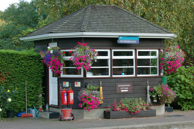
The 1890-built lockside office at Old Windsor was presented by the Environment Agency to the River & Rowing Museum at Henley. Still carrying the name of the then lock keeper (J C Jack Dyer), the small wooden office is a rare reminder of lock keeping memorabilia.
The River & Rowing Museum is closed to the public. Its current notice explains the transfer of its collections. The office’s donation is retained here as history, not a promise that it can presently be visited in Henley.
Why the lock sits in a cut
Windsor Local History Group dates the lock to 1822 and describes its channel as a shortcut around the river loop enclosing Ham Fields. The straight navigation cut and the older curving river therefore tell different parts of the landscape’s story. The first-lock date does not date today’s operating equipment.
Research source: Windsor Local History Group. Checked 4 October 2026.
EXPLORE THE THAMES
Wildlife at Old Windsor Lock
The following wildlife details are retained from our earlier local account, not a current survey or a guarantee of sightings.
The original local account records a wide variety of wildlife here, including lesser spotted woodpeckers, goshawk, kingfishers and many others. It also records snakes swimming across the river here.
ON THE WATER
Boating through Old Windsor Lock
Romney Lock is 4.83 km (3.00 miles) upstream. The next lock downstream is Bell Weir Lock, 4.70 km (2.92 miles) away by river.
Published lock dimensions
- Length
- 54.55 m
- Width
- 7.36 m
- Fall
- 1.74 m
- Upper sill depth
- 2.48 m
- Lower sill depth
- 2.54 m
Source: Environment Agency distances and measurements. Published dimensions and sill depths do not guarantee navigable clearance. Check water levels, the full guidance and current restrictions.
Consult the lock keeper service and follow the instructions displayed at the lock.
Neighbouring reaches: cruising estimates
| Reach | km / miles | EA estimate |
|---|---|---|
| Romney → Old Windsor | 4.83 / 3.00 | 37 minutes |
| Old Windsor → Bell Weir | 4.70 / 2.92 | 36 minutes |
The Environment Agency estimates assume 8 km/h. Add waiting and lock-passage time; conditions can lengthen journeys. These are river distances, not walking distances.
Facilities at Old Windsor Lock
- toilet
- drinking water tap (for portable containers only)
- electric charging point - currently closed
Checked 4 October 2026 against the Environment Agency facilities guide. Availability can change; check the official guide and signs on site.
The Environment Agency also gives an approximate 2.6 m beam limit for access to the electric charging point, which it currently lists as closed. This is a charging-point restriction, not the lock’s chamber width.
BEFORE YOU SET OFF
River conditions at Old Windsor Lock
Check stream warnings and navigation closures separately. A lack of stream warnings does not confirm that a lock is open.
For the latest information, check the official river conditions service below.
Questions about Old Windsor Lock
Where is Old Windsor Lock?
It is at Old Windsor on the Thames, between Romney Lock and Bell Weir Lock.
Why does the lock look like an amphitheatre?
Stone steps flank both sides of the chamber, giving it the appearance of a small Roman amphitheatre.
Can I see the old lock office at the River & Rowing Museum?
The office was donated to the museum, but the museum is closed to the public. Check its collection information for the latest position.
About this guide
Published by The River Thames Guide. Research additions, measurements and facilities checked 4 October 2026. Sources are linked beside new material; earlier local accounts are retained where identified. Check changing access and navigation arrangements before travelling.
Contains public sector information licensed under the Open Government Licence v3.0. New research is written in original wording; no third-party archive images or maps have been copied. Existing photograph credits and licences are retained.


