 The River Thames Guide
EXPLORE THE THAMES
Visiting Romney Lock
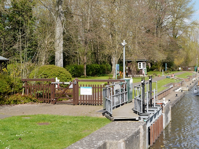
Romney Lock is near Windsor Castle and Eton, between Boveney and Old Windsor locks. Plan your public walking route using the official Thames Path map. The postcode in this guide locates the lock; check parking and the final approach separately.
Combine the riverside with a visit to Windsor or Eton, checking attraction opening and ticket arrangements separately.
Plan a Windsor and Eton visit
Use the public Thames Path route to connect your lock visit with Windsor or Eton. The lock’s postcode is not a parking instruction, and its facilities list does not promise visitor toilets: the Environment Agency currently lists a drinking-water tap for portable containers only.
EA facilities guide, checked 4 October 2026.
EXPLORE THE THAMES
Windsor Castle, Eton and water power
From Romney Lock there are views towards Eton College and its grounds. Nearby Windsor Castle is a royal residence.
The large Victorian red-brick Grade II listed pumping station beside the lock supplied water to the castle. The original guide describes its giant metal turbines, later superseded by electric power; it is not a public viewing attraction.
A later hydro power scheme at Romney Weir supplies electricity to Windsor Castle, as confirmed by the Royal Household. The earlier guide’s £1m proposal, end-of-2006 target and one-third power estimate described plans at that time, rather than current operating figures.
EXPLORE THE THAMES
Romney Lock’s unusual early names
Documents record that where Romney Lock now stands, there was a flash lock in the 15 th century. It was then called Bullokeslok, and it made up part of a fishery named Cokkeshole. The origins of these names remain a mystery....and we won't attempt to guess.
A wooden pound lock was built here by the Thames Navigation Commissioners, then rebuilt by the Thames Conservancy in 1869 and yet again by the Thames Water Authority in 1979/80, this time using underwater sluices to fill and empty the chamber.
A lock shaped by the towing horses’ route
Windsor Local History Group dates the first lock to 1798, after prolonged debate over its position. One argument for the scheme concerned the difficult river crossing made by barge horses above Windsor Bridge. The chosen lock cut lay downstream of the bridge, beside Eton College. Its location reflects the needs of freight navigation long before modern leisure cruising.
Research source: Windsor Local History Group. Checked 4 October 2026.
EXPLORE THE THAMES
Wildlife at Romney Lock
The following wildlife details are retained from our earlier local account, not a current survey or a guarantee of sightings.
A wide variety of wildlife congregates here at the lock, including kingfishers and blackcaps, jays, sparrowhawks, hobbies, coal tits, Mandarin ducks, nuthatch and the tiny firecrest.
ON THE WATER
Boating through Romney Lock
Boveney Lock is 3.75 km (2.33 miles) upstream. The next lock downstream is Old Windsor Lock, 4.83 km (3.00 miles) away by river.
Published lock dimensions
- Length
- 78.50 m
- Width
- 7.45 m
- Fall
- 2.01 m
- Upper sill depth
- 2.83 m
- Lower sill depth
- 2.62 m
Source: Environment Agency distances and measurements. Published dimensions and sill depths do not guarantee navigable clearance. Check water levels, the full guidance and current restrictions.
Consult the lock keeper service and follow the instructions displayed at the lock.
Neighbouring reaches: cruising estimates
| Reach | km / miles | EA estimate |
|---|---|---|
| Boveney → Romney | 3.75 / 2.33 | 29 minutes |
| Romney → Old Windsor | 4.83 / 3.00 | 37 minutes |
The Environment Agency estimates assume 8 km/h. Add waiting and lock-passage time; conditions can lengthen journeys. These are river distances, not walking distances.
Facilities at Romney Lock
- drinking water tap (for portable containers only)
Checked 4 October 2026 against the Environment Agency facilities guide. Availability can change; check the official guide and signs on site.
BEFORE YOU SET OFF
River conditions at Romney Lock
Check stream warnings and navigation closures separately. A lack of stream warnings does not confirm that a lock is open.
For the latest information, check the official river conditions service below.
Questions about Romney Lock
Where is Romney Lock?
It is close to Windsor Castle, with views towards Eton, between Boveney and Old Windsor locks.
What is the building beside Romney Lock?
It is the historic castle water pumping station, a Grade II listed Victorian building. Its interior is not a public attraction.
Does Romney Weir generate power for Windsor Castle?
Yes. The Royal Household identifies hydroelectricity produced at Romney Weir as a source of electricity for the castle.
About this guide
Published by The River Thames Guide. Research additions, measurements and facilities checked 4 October 2026. Sources are linked beside new material; earlier local accounts are retained where identified. Check changing access and navigation arrangements before travelling.
Contains public sector information licensed under the Open Government Licence v3.0. New research is written in original wording; no third-party archive images or maps have been copied. Existing photograph credits and licences are retained.


