 The River Thames Guide
EXPLORE THE THAMES
Visiting Rushey Lock
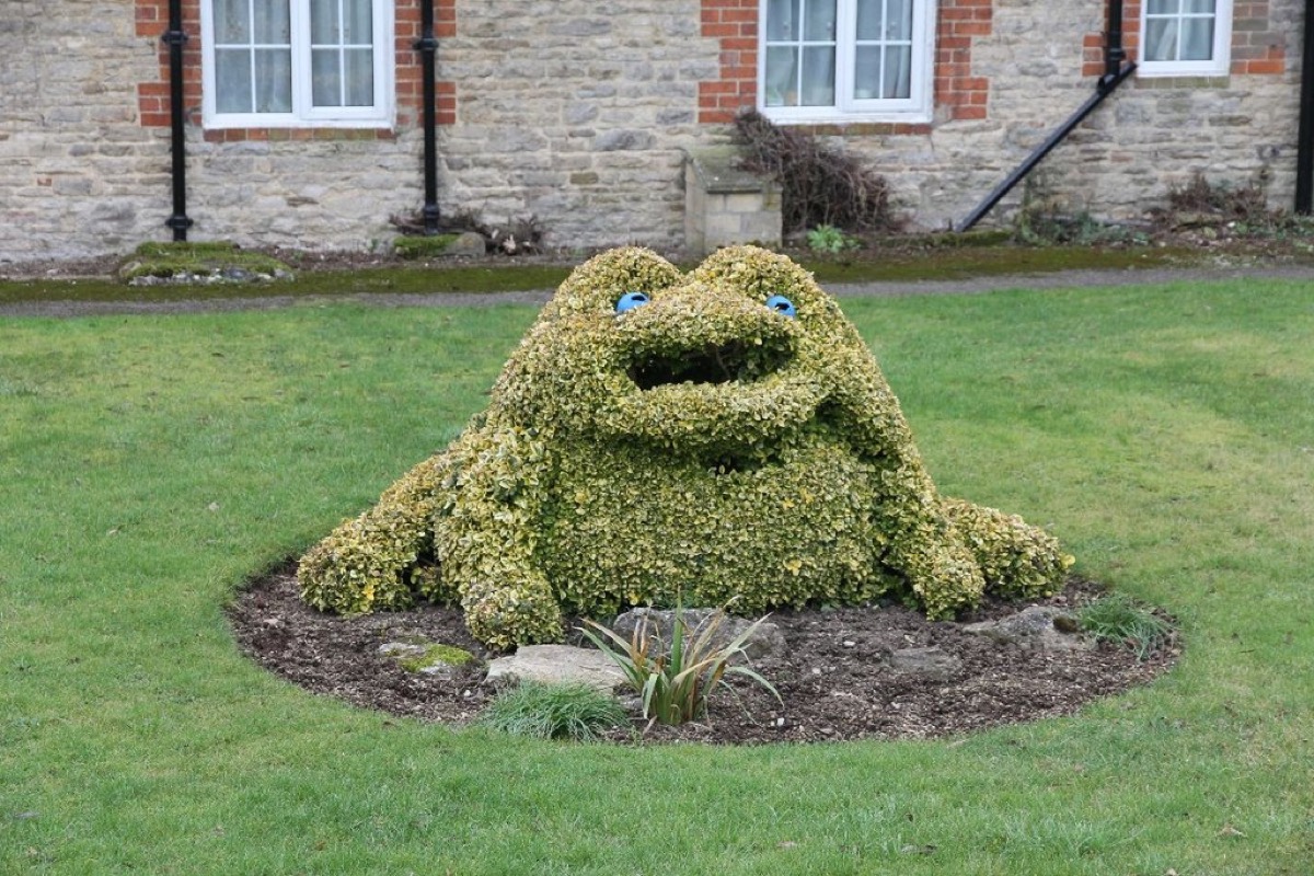
Rushey is one of the rural locks of the upper Thames, near Buckland Marsh and Faringdon. Its garden and distinctive topiary have long made it a favourite subject for photographs.
Plan your approach with the official Thames Path route map. The lock postcode is SN7 8RF; check public footpaths and parking arrangements rather than assuming the postcode gives public vehicle access.
For angling, consult the Environment Agency’s Rushey fishing site guide for the designated area and access information. Check current permits and restrictions before fishing.
Approaching from Tadpole Bridge
The Environment Agency’s fishing site guide describes the access path running west, upstream, from Tadpole Bridge. It states that there is no car parking at the lock and identifies roadside parking at Tadpole Bridge. Follow current local signs and avoid blocking access.
EXPLORE THE THAMES
The frog in the garden and the former guest house
Rushey is known in our original guide as “the lock with the frog in the garden”. The giant topiary frog in the lock keeper’s garden has attracted photographers for many years.
The keeper’s house also has a celebrity story. The earlier account describes its former life as a guest house visited by Errol Flynn, the Astors and Douglas Fairbanks. These are local historical recollections, not a description of accommodation currently available at the lock.
EXPLORE THE THAMES
The history of Rushey Lock and Weir
The origin of the name Rushey is uncertain, although rushes are common along this stretch of river. The original guide recalls their use in weaving mats, chairs and baskets, and in paper-making.
Following William Jessop’s survey of the Thames, Rushey was one of six stone locks built during 1787–91. The others were St John’s, Buscot, Pinkhill, Godstow and Osney. Rushey’s stone lock was built in 1790. An earlier flash lock stood about a mile upstream at Old Nan’s (or Man’s) Bridge, a site considered unsuitable for the new pound lock.
The Oxford Archaeology survey (PDF) reproduces the statutory listing’s record of the lock rebuilt and dated 1896. Its heavy wooden operating beams preserve the traditional character described in our original guide.
The paddle and rymer weir
The earlier page described wooden walkways, railings and a well-preserved paddle and rymer weir. That description needs historical context: the Environment Agency’s weir improvement programme set out plans to replace the ageing Rushey structure while keeping a small heritage element. Check the official project information when researching the weir’s development.
Paying by the ton
Thacker records Rushey opening in winter 1790 with a toll of two and a half old pence per ton: a reminder of the cargo trade behind the navigation.
Research source: F. S. Thacker, The Thames Highway: Rushey. Checked 6 October 2026.
EXPLORE THE THAMES
Birdwatching around Rushey Lock
These wildlife details come from our earlier local account, not a current survey or a guarantee of sightings.
Our local wildlife account records buzzards, red kites, kingfishers, whinchats, siskins and goosanders. The river, banks and surrounding countryside offer different habitats, so the birds seen will vary through the year.
Allow time to pause and watch from public paths. Keep dogs under control and avoid disturbing nesting birds.
ON THE WATER
Boating through Rushey Lock
Radcot Lock is 4.23 km (2.63 miles) upstream. The next lock downstream is Shifford Lock, 6.92 km (4.30 miles) away by river.
Published lock dimensions
- Length
- 34.59 m
- Width
- 4.59 m
- Fall
- 1.82 m
- Upper sill depth
- 1.67 m
- Lower sill depth
- 1.52 m
Source: Environment Agency distances and measurements. Published dimensions and sill depths do not guarantee navigable clearance. Check water levels, the full guidance and current restrictions.
Consult the lock keeper service and follow the instructions displayed at the lock.
Neighbouring reaches: cruising estimates
| Reach | km / miles | EA estimate |
|---|---|---|
| Radcot → Rushey | 4.23 / 2.63 | 32 minutes |
| Rushey → Shifford | 6.92 / 4.30 | 52 minutes |
The Environment Agency estimates assume 8 km/h. Add waiting and lock-passage time; conditions can lengthen journeys. These are river distances, not walking distances.
Facilities at Rushey Lock
- toilet (accessible)
- shower – currently closed
- drinking water tap (for portable containers only)
- chemical toilet disposal
- sewage pump-out
- refuse disposal
Checked 6 October 2026 against the Environment Agency facilities guide. Availability can change; check the official guide and signs on site.
Dry-weather passage restrictions
Checked 6 October 2026: the EA still lists restrictions from St John’s to Osney, covering this lock. Passages during keeper hours are limited to one movement each way per half-hour. Overnight closures run from 30 minutes before duty ends until 30 minutes after duty starts the next day. Check current hours and the full notice when planning your arrival.
EA dry-weather navigation notice; arrangements remain subject to review.
BEFORE YOU SET OFF
River conditions at Rushey Lock
Check stream warnings and navigation closures separately. A lack of stream warnings does not confirm that a lock is open.
For the latest information, check the official river conditions service below.
Questions about Rushey Lock
What is Rushey Lock known for?
Rushey is particularly associated with the giant topiary frog in the lock keeper’s garden and its rural setting on the upper Thames.
Which locks are next to Rushey?
Radcot is upstream and Shifford is downstream. Use the published river distances below for boating journey planning.
Are there toilets at Rushey Lock?
The Environment Agency lists an accessible toilet. The shower is listed as closed. Facility availability can change, so check the official guide.
About this guide
Published by The River Thames Guide. Research additions, measurements and facilities checked 6 October 2026. Sources are linked beside new material; earlier local accounts are retained where identified. Check changing access and navigation arrangements before travelling. The older description of the weir is retained as history alongside the Environment Agency’s improvement programme.
Contains public sector information licensed under the Open Government Licence v3.0. New research is written in original wording; no third-party archive images or maps have been copied. Existing photograph credits and licences are retained.


